Dust Off The Shovels: Quick Burst Of Snow Targets Mid-Atlantic, I-95 Corridor
Update (Saturday morning):
Dust off your snow shovels and fill up those snowblowers with gasoline, or if you’ve splurged this year on a fancy robot snowblower, plug it in and charge the batteries today.
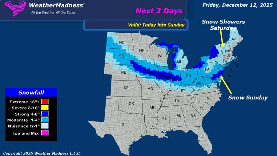
The Mid-Atlantic and Northeast are preparing for the season’s first significant snowfall event, with accumulating snow expected in metro areas near I-95. It is a fast-moving clipper storm expected to arrive overnight.
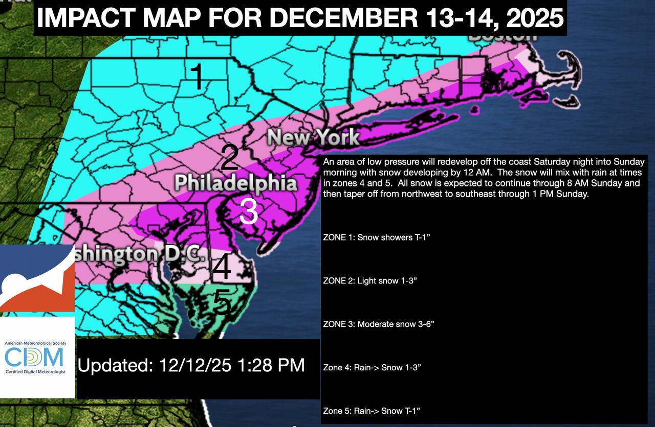
“An area of low pressure will redevelop off the coast Saturday night into Sunday morning with snow developing by 12 a.m. The snow will mix with rain at times in Zones 4 and 5. All snow is expected to continue through 8 a.m. Sunday and then taper off from northwest to southeast through 1 p.m. Sunday,” a meteorologist at NY NJ PA Weather wrote in a report.
NY NJ PA Weather noted that the heaviest snowfall favors interior areas, while coastal zones may see periods of rain before transitioning to snow. Accumulating snow is possible near the I-95 corridor, including areas around Washington, D.C., Philadelphia, and New York City.
Impacts by zone (courtesy of NY NJ PA Weather):
-
Zone 1: Snow showers, trace to 1 inch
-
Zone 2: Light snow, 1 to 3 inches
-
Zone 3: Moderate snow, 3 to 6 inches
-
Zone 4: Rain changing to snow, 1 to 3 inches
-
Zone 5: Rain changing to snow, trace to 1 inch
What other meteorologists and weather observers are saying:
DECEMBER 14 SNOW FORECAST
A plowable snow of 3-5″ is expected for snow starved areas near and below I-95 from Baltimore to the Cape. Fairly bullish due to favorable snow growth and banding potential. Less snow as one moves inland. Will be in and out before noon Sunday. pic.twitter.com/jhgUP2C4dm
— Andrew Markowitz (@amarkowitzWX) December 12, 2025
00z RRFS much more enthusiastic than the NAM suite pic.twitter.com/Ef45nrQ9CS
— Michael Kiefer (@mike61400) December 13, 2025
Winter weather advisory 8p-7a tonight. Weather Service is calling for 1-3 inches, which is somewhat higher than our coating to 2 inches.
Heaviest totals around Baltimore and northeast Md. Snow Potential Index a 7. Much colder Sun-Mon. Forecast details: https://t.co/2sM0zHeo9V pic.twitter.com/TtPmveSTrh
— Capital Weather Gang (@capitalweather) December 13, 2025
❄️ANOTHER WINTER STORM IS COMING❄️
A strong Alberta Clipper Snow Storm will bring significant accumulating snow to the Midwest and Ohio Valley on Saturday.Widespread Snow of 3–6 inches is expected, with some of the hardest hit cities including Springfield IL, Indianapolis,… pic.twitter.com/4Cf5mWh2oy
— Brady Harris (@StormCat5_) December 13, 2025
Related:
* * *
Ahead of next week’s return to global warming, thank you, Al Gore, for listening to our prayers in the Mid-Atlantic and Northeast after weeks of below-average temperatures that felt like the Arctic. A weekend snowstorm is set to blanket the region with accumulating snow.
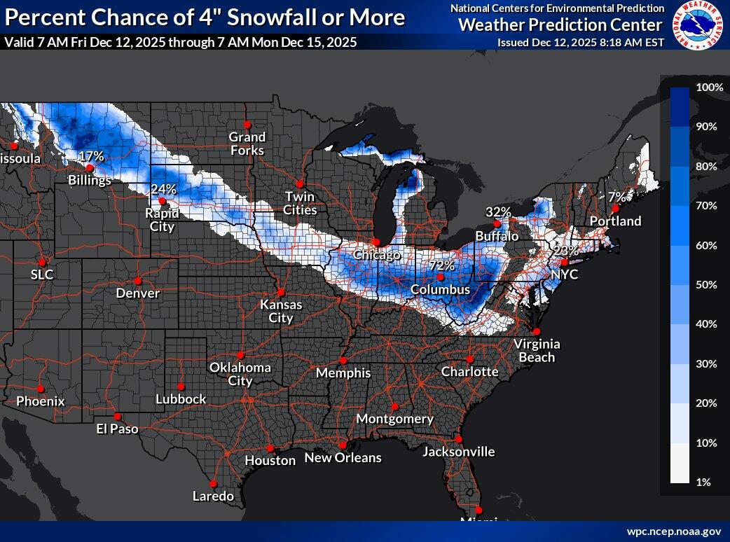
The NWS Weather Prediction Center published a new snowfall forecast for a weekend winter storm that stretches from the northern High Plains of Montana through the Ohio Valley, the central Appalachians, and the Northeast, including major cities from Washington, D.C., to Baltimore, Philadelphia, New York City, and Boston.
Private weather forecaster Weather Madness noted on X, “I expect an Arctic low to develop along the Arctic front, which could produce extra snow along the I-95 corridor from NYC to DCA.”
Weather Madness expects parts of the Mid-Atlantic to receive 4 to 8 inches.
Meteorologist Steven DiMartino at NY NJ PA Weather published a short video earlier that details the incoming snow threat for the Mid-Atlantic area.
Snowfall On The Way!
A premium public discussion focused on the snow threat for Sunday morning. pic.twitter.com/OtGWW5Mr37
— NY NJ PA Weather (@nynjpaweather) December 12, 2025
More from meteorologist Rayn Maue…
Mother Nature will take out her paint brush and color in the Northeast along the coast including NYC and Boston with “blue coloring” or more than 2″ of snowfall ❄️and then just about everyone will have had snow before December 15th.
That’s a successful pre-winter! pic.twitter.com/A8cKE8Qjej
— Ryan Maue (@RyanMaue) December 12, 2025
On Thursday, we noted in “After Polar Vortex US Freeze, Global Warming Returns Before Christmas” that a warm-up for the eastern half of the US is expected to begin on Tuesday-Wednesday of next week.
Related:
Meteorologist Ben Noll said, “A whopping 235 million people across the United States have experienced well below-average temperatures so far this December.”
Next week, much milder air from the West will erase the chill in the East.
There are signs these warmer conditions may stick around leading up to Christmas. pic.twitter.com/0AlWkQYWvp
— Ben Noll (@BenNollWeather) December 12, 2025
We’ll take the warmth. Thanks, Al Gore. However, January is right around the corner.
Tyler Durden
Sat, 12/13/2025 – 07:48
ZeroHedge News
[crypto-donation-box type=”tabular” show-coin=”all”]