Polar Vortex Threat Sends US NatGas Futs To Highest Level Since 2022
Update (1110ET):
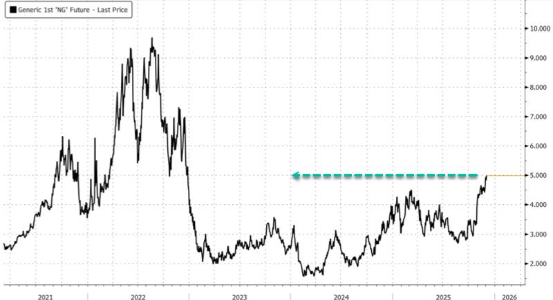
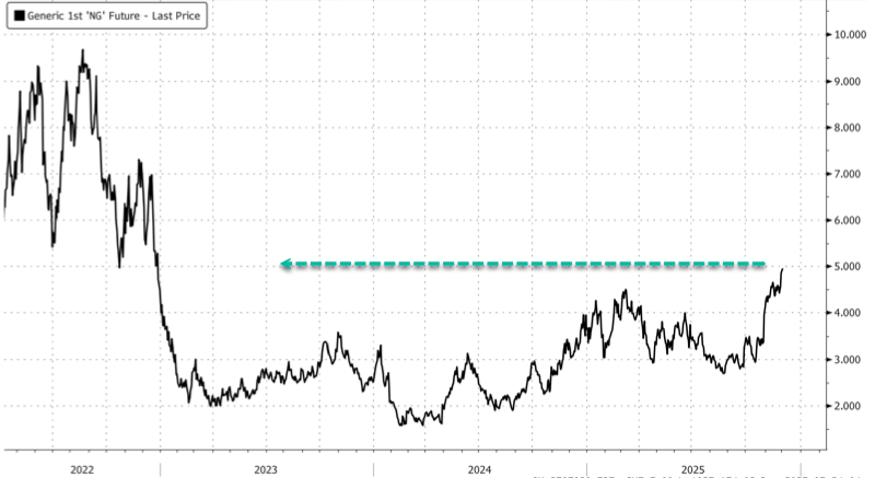
U.S. natural gas futures jumped above $5 per MMBtu, the highest level since December 2022, as traders expect colder-than-normal temperatures across the Lower 48 in the first half of December.
Meteorologists, such as Mark Margavage, are focused on a polar vortex threat that could “dump the motherload of cold into Eastern North America in the coming weeks.”
The Polar Vortex looks like it’s about to dump the motherload of cold into Eastern North America in the coming weeks… this is only enhanced by the MJO happening to be in Phase 8. Wild times ahead.#PolarVortex #PV #winteriscoming #wxtwitter #wxX pic.twitter.com/aRX8X52D5x
— Mark Margavage (@MeteoMark) December 3, 2025
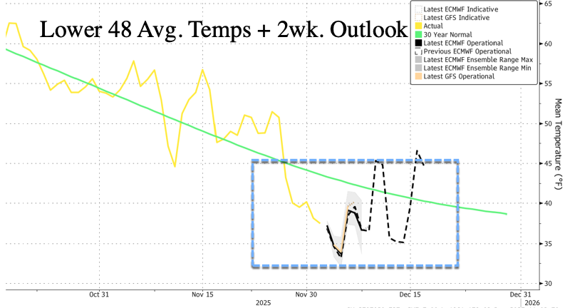
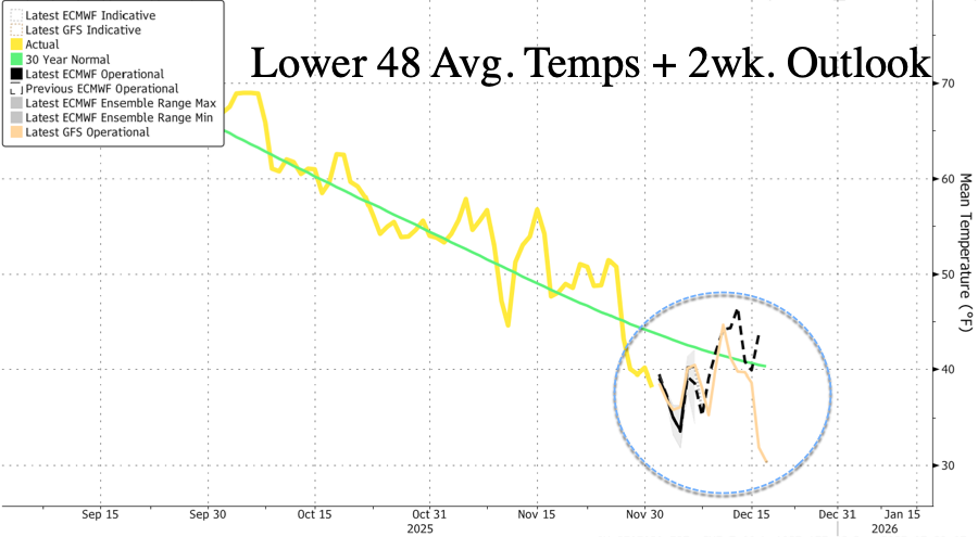
Forecasted Lower 48 average temperatures for the next two weeks will be well below the 30-year average.
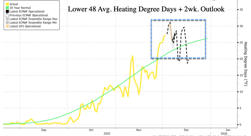
As a result, heating demand soars…
Here’s what other meteorologists are saying:
DOZENS OF RECORDS will be crushed Thursday and Friday!
Temperatures will tumble up to 40° BELOW average with this intense shot of polar air! pic.twitter.com/YSWZVa95zU
— Max Velocity (@MaxVelocityWX) December 3, 2025
An area including the United States and Canada will form the most extensive zone of below-average temperatures on the planet over the next 10 days.
But context is important: it won’t be unusually cold everywhere.
65 percent of the planet will have above-average temperatures. pic.twitter.com/yFGEbDu8Kt
— Ben Noll (@BenNollWeather) December 3, 2025
Overnight changes on both EPS and GEFS ensembles next week.
The pattern just doesn’t support anything other than WINTER in the east imho.
The models have been doing this for a month now.
The setup is cold and active.
Period. pic.twitter.com/rrdRNWxuhm— BAM Weather (@bam_weather) December 3, 2025
Brrr.
* * *
U.S. natural gas futures spiked to their highest levels in nearly three years as models now show a frigid first half of December across the Lower 48. Several forecasters are also warning of a potential polar-vortex-driven Arctic blast event later this month, which could drive temperatures even lower.
Let’s begin with an unusual sight (for this time of year) of winter storm alerts across the Northeast on Tuesday morning.
🚨 WINTER STORM TODAY 🚨
Heavy snow (5-10″ expected) in the Interior Northeast & disruptive ice (up to 0.2″ accretion) in the Central Appalachians will make today’s commutes HAZARDOUS. The storm exits by Wednesday morning. pic.twitter.com/kkcnacF82O— NWS Weather Prediction Center (@NWSWPC) December 2, 2025
NatGas futures are on track for their largest quarterly gain since the first quarter of 2022. Prices on Tuesday morning were trading near $5 per mmbtu, the highest level since December 2022. The rally is being fueled by a rapid shift toward colder early-December temperatures across the Midwest and East, which has boosted heating demand expectations.
Weather models turned colder across the eastern two-thirds of the country for Dec. 6 to 10, with additional cooling expected for Dec. 11 to 15. These forecasts merely reinforce expectations for a near-term spike in residential and commercial heating loads.
Meteorologist Ryan Maue warned on X that the stratospheric polar vortex over the North Pole is set for another warming event in about two weeks.
The stratospheric “polar vortex” above the North Pole is loading up yet another “sudden warming” event in 2-weeks.
After most extreme observed November SSW event, we’re hitting multiplier x2 — re-spinning the whole thing.
Told you already we’re going to see the “full load” pic.twitter.com/tgcBsmHsyA
— Ryan Maue (@RyanMaue) December 1, 2025
“It’s going to be a long, cold winter,” Maue noted in another post.
Monday Winter Weather December 1, 2025
Negative Arctic Oscillation (-AO) is a bad omen with yet another stratospheric sudden warming (SSW) event –> it’s going to be a long, cold winter
Free to read (sign up / email) @weathertrader https://t.co/MaNEqL87GM pic.twitter.com/OpAT7uKunV
— Ryan Maue (@RyanMaue) December 1, 2025
Meteorologist Judah Cohen stated, “IMO next PV stretch keeps cold train coming in Eastern US up to the holidays.”
The weather pattern is in “rinse, lather, repeat” mode or in #PolarVortex (PV) parlance, one good stretch deserves another. IMO next PV stretch keeps cold train coming in Eastern US up to the holidays. Also first ever N Hemisphere snowfall forecast in blog https://t.co/CGUOIWUvOO pic.twitter.com/v2rQz182wb
— Judah Cohen (@judah47) December 2, 2025
Greta Thunberg’s sudden pivot to all things Palestine and Bill Gates’ open acknowledgment that much of the climate-crisis narrative was overblown only reinforce what’s becoming obvious: the climate-crisis narrative has collapsed like a house of cards. And with the Northeast already plunged into an early-season chill, spare us … we could certaintly use a little “global warming” right about now.
Tyler Durden
Wed, 12/03/2025 – 11:10
ZeroHedge News
[crypto-donation-box type=”tabular” show-coin=”all”]